


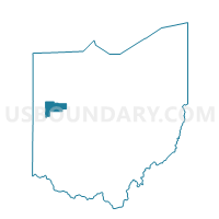
WASHINGTON Voting District, Auglaize County, Ohio
About
Outline

Summary
| Unique Area Identifier | 642872 |
| Name | WASHINGTON Voting District |
| County | Auglaize County |
| State | Ohio |
| Area (square miles) | 30.18 |
| Land Area (square miles) | 30.18 |
| Water Area (square miles) | 0.00 |
| % of Land Area | 99.99 |
| % of Water Area | 0.01 |
| Latitude of the Internal Point | 40.51977720 |
| Longtitude of the Internal Point | -84.27976070 |
Maps


Graphs
Select a template below for downloading or customizing gragh for WASHINGTON Voting District, Auglaize County, Ohio


Neighbors
Neighoring Voting District (by Name) Neighboring Voting District on the Map
- DINSMORE Voting District, Shelby County, OH
- DUCHOUQUET W Voting District, Auglaize County, OH
- MOULTON Voting District, Auglaize County, OH
- NEW KNOXVILLE Voting District, Auglaize County, OH
- PUSHETA Voting District, Auglaize County, OH
- ST. MARYS E Voting District, Auglaize County, OH
- VAN BUREN NORTH Voting District, Shelby County, OH
Top 10 Neighboring County Subdivision (by Population) Neighboring County Subdivision on the Map
- Duchouquet township, Auglaize County, OH (14,499)
- St. Marys township, Auglaize County, OH (11,015)
- Dinsmore township, Shelby County, OH (3,477)
- Van Buren township, Shelby County, OH (2,077)
- Washington township, Auglaize County, OH (1,874)
- Moulton township, Auglaize County, OH (1,694)
- Pusheta township, Auglaize County, OH (1,301)
Top 10 Neighboring Place (by Population) Neighboring Place on the Map
Top 10 Neighboring Unified School District (by Population) Neighboring Unified School District on the Map
- Wapakoneta City School District, OH (19,151)
- St. Marys City School District, OH (13,272)
- Anna Local School District, OH (5,433)
- New Bremen Local School District, OH (4,641)
- Botkins Local School District, OH (2,351)
- New Knoxville Local School District, OH (1,857)
Top 10 Neighboring State Legislative District Lower Chamber (by Population) Neighboring State Legislative District Lower Chamber on the Map
Top 10 Neighboring State Legislative District Upper Chamber (by Population) Neighboring State Legislative District Upper Chamber on the Map
Top 10 Neighboring 111th Congressional District (by Population) Neighboring 111th Congressional District on the Map
Top 10 Neighboring Census Tract (by Population) Neighboring Census Tract on the Map
- Census Tract 404, Auglaize County, OH (6,712)
- Census Tract 9715, Shelby County, OH (5,222)
- Census Tract 405, Auglaize County, OH (5,021)
- Census Tract 411, Auglaize County, OH (3,992)
- Census Tract 406, Auglaize County, OH (3,851)